1

Saturday, May 25, 2013

Gateshead Millennium Bridge

The Gateshead Millennium Bridge is a pedestrian and cyclist tilt bridge spanning the River Tyne in England between Gateshead's Quays arts quarter on the south bank, and the Quayside of Newcastle upon Tyne on the north bank. The award-winning structure was conceived and designed by architects Wilkinson Eyre and structural engineers Gifford. The bridge is sometimes referred to as the 'Blinking Eye Bridge' or the 'Winking Eye Bridge' due to its shape and its tilting method. In terms of height, the Gateshead Millennium Bridge is slightly shorter than the neighbouring Tyne Bridge, and stands as the sixteenth tallest structure in the city.

The Gateshead Millennium Bridge is a pedestrian and cyclist tilt bridge spanning the River Tyne in England between Gateshead's Quays arts quarter on the south bank, and the Quayside of Newcastle upon Tyne on the north bank. The award-winning structure was conceived and designed by architects Wilkinson Eyre and structural engineers Gifford. The bridge is sometimes referred to as the 'Blinking Eye Bridge' or the 'Winking Eye Bridge' due to its shape and its tilting method. In terms of height, the Gateshead Millennium Bridge is slightly shorter than the neighbouring Tyne Bridge, and stands as the sixteenth tallest structure in the city.

Photo — Link

Design — The bridge was lifted into place in one piece by the Asian Hercules II, one of the world's largest floating cranes, on 20 November 2000. It was opened to the public on 17 September 2001, and was dedicated by Queen Elizabeth II on 7 May 2002. The bridge, which cost £22m to build, was part funded by the Millennium Commission and European Regional Development Fund. It was built by Volker Stevin.

Six 45 cm (18 in) diameter Hydraulic rams (three on each side, each powered by a 55 kW electric motor) rotate the bridge back on large bearings to allow small ships and boats (up to 25 m (82 ft) tall) to pass underneath. The bridge takes as little as 4.5 minutes to rotate through the full 40° from closed to open, depending on wind speed. Its appearance during this manoeuvre has led to it being nicknamed the "Blinking Eye Bridge". 13 more images after the break...

Pamban Bridge — India

The Pamban Bridge  is a cantilever bridge on the Palk Strait connects Rameswaram on Pamban Island to mainland India. It refers to both the road bridge and the cantilever railway bridge, though primarily it means the latter. It was India's first sea bridge. It is the second longest sea bridge in India (after Bandra-Worli Sea Link) at a length of about 2.3 km. The rail bridge is for the most part, a conventional bridge resting on concrete piers, but has a double leaf bascule section midway, which can be raised to let ships and barges pass through. The railway bridge is 6,776 ft (2,065 m) and was opened for traffic in 1914. The railroad bridge is a still-functioning double-leaf bascule bridge section that can be raised to let ships pass under the bridge.

The Pamban Bridge  is a cantilever bridge on the Palk Strait connects Rameswaram on Pamban Island to mainland India. It refers to both the road bridge and the cantilever railway bridge, though primarily it means the latter. It was India's first sea bridge. It is the second longest sea bridge in India (after Bandra-Worli Sea Link) at a length of about 2.3 km. The rail bridge is for the most part, a conventional bridge resting on concrete piers, but has a double leaf bascule section midway, which can be raised to let ships and barges pass through.

Photo — Link

The railway bridge historically carried metre-gauge trains on it, but Indian Railways upgraded the bridge to carry broad-gauge trains in a project that finished Aug. 12, 2007. Until recently, the two leaves of the bridge were opened manually using levers by workers. About 10 ships — cargo carriers, coast guard ships, fishing vessels and oil tankers — pass through the bridge every month. From the elevated two-lane road bridge, adjoining islands and the parallel rail bridge below can be viewed.

After completion of bridge metre-gauge lines were laid by them from Mandapam up to Pamban Station, from here the railway lines bifurcated into two directions one towards Rameshwaram about 6.25 miles (10.06 km) up and another branch line of 15 miles (24 km) terminating at Dhanushkodi. The section was opened to traffic in 1914. 09 more images after the break...

Wednesday, May 8, 2013

Top 10 Most Walkable Cities in the United States

10. Portland, OR

Population: 2.14 million
% commute by walking: 2.8%
% commute by mass transit: 5.9%
Average commute: 25.3 minutes
Number of parks: 39.5

09 Cities more after the break...

Failed Truck

Failed trucking, 21 more images after the break...

Tuesday, May 7, 2013

Shuvalov Bell Factory


There is certainly something fascinating about bells. They are not just tools for producing high-quality and extraordinary clear sounds. Bell is also a means of fellowship of God and people. Somehow, bells draw His attention to something that’s happening in a church. For toll can be a festive or a mournful thing; it also can inform one of good news or just please your ear with music that the toller makes, 12 more images after the break...

Sunday, May 5, 2013

Crazy Mix


Crazy Mix, 25 more images after the break...

The Largest Pair of Jeans Ever


Seamstresses in Peru decided to get to the Guinness World Record for the largest pair of jeans ever. The pair of jeans measures 141 feet tall and 98 feet wide and weighs in at 7.5 tons. The current record is held by the city of Medellin in Columbia. That pair was 114 feet tall and 82 feet wide. It sounds like they are just waiting for their record setting jeans to be accepted by Guinness. There wasn’t a Guinness representative present, but a notary who can send documentation to the group was. The pants will be recycled as backpacks for school children. [via DamnCoolPics] More images after a break.......

New tower in the Emirates — Nakheel Tower


The latest design attempting to breach the dizzying heights of the Burj Dubai has been revealed as the multibillion dollar Nakheel Tower. Designed by the developments wing of major investment company Nakheel, the tower will be more than a kilometre high, covering a space of around 270 hectares, and will become home to around 55,000 people, a workplace for 45,000, and is hoped will attract millions of visitors each year. 09 more images and video after the break...

Friday, May 3, 2013

Hotelicopter - Flying Hotel

Wow, the flying hotel and largest helicopter in the world, Cool! The Hotelicopter is modeled on the Soviet-made Mil V-12, of which there were only two prototypes ever made. The Hotelicopter Company purchased one of these prototypes from the Mikhail Leontyevich Mil helicopter plant in Panki-Tomilino, Russia in 2004 and have been engineering the world's first flying hotel ever since."The Hotelicopter features 18 luxuriously-appointed rooms for adrenaline junkies seeking a truly unique and memorable travel experience. More after the break...

Money Facts

  • The word millionaire was first used by Benjamin Disraeli in his 1826 novel Vivian Grey.
  • If you stack one million US$1 bills, it would be 110m (361 ft) high and weight exactly 1 ton.

  • A million dollars' worth of $100 bills weighs only 10 kg (22 lb).

  • One million dollars' worth of once-cent coins (100 million coins) weigh 246 tons.

  • TIP is the acronym for "To Insure Promptness."

  • The term "Blue Chip" comes from the colour of the poker chip with the highest value, blue.
    (Read more facts after the break...)

Interesting Facts

  • The microwave was invented after a researcher walked by a radar tube and a chocolate bar melted in his pocket.
  • The military salute originated during the medieval times. Knights in armor used to raise their visors to reveal their identity, and the motion later evolved into the modern-day salute.
  • The Mills Brothers have recorded the most songs of any artist: about 2,250.
  • The minarets ofthe Taj Mahal in India are angled at 88 degrees outwards so that they would not collapse into the structure should an earthquake occur. Read more after the break...

The Enigmatic Moray Agricultural Terraces of the Incas

One of the most visually stunning Inca ruins is at Moray, an archaeological site in Peru approximately 50 km northwest of Cuzco and just west of the village of Maras. In a large bowl-like depression, is constructed a series of concentric terraces that looks like an ancient Greek amphitheater. The largest of these terraces are at the center – they are enormous in size, and descend to a depth of approximately 150 meter, leading to a circular bottom so well drained that it never completely floods, no matter how plentiful the rain.

The concentric terraces are split by multiple staircases that extend upward like spokes of a wheel and enable people to walk from the top to the bottom of the bowl. Six more terraces, in connected ellipses rather than perfect circles, surround the concentric heart of Moray, and eight terraced steps that cover only a fraction of the perimeter overlook the site. The purpose of these depressions is uncertain, but the most widely agreed theory is they used to serve as ‘agricultural research station’.

One of the most visually stunning Inca ruins is at Moray, an archaeological site in Peru approximately 50 km northwest of Cuzco and just west of the village of Maras. In a large bowl-like depression, is constructed a series of concentric terraces that looks like an ancient Greek amphitheater. The largest of these terraces are at the center – they are enormous in size, and descend to a depth of approximately 150 meter, leading to a circular bottom so well drained that it never completely floods, no matter how plentiful the rain.

Photo — Link

One of the most remarkable feature of the site is the vast difference in temperature that exist between the top and the bottom reaches of the structure, which can be as much as 15°C. This large temperature difference created micro climates, similar to what is achieved in greenhouses in modern times, that was possibly used by the Inca to study the effects of different climatic conditions on crops.

It is no coincidence that the temperature difference corresponds to the natural difference between coastal sea level farmland and Andean farming terraces 1,000 meters about sea level. Furthermore, pollen studies indicate that soils from different regions of the Inca empire was imported to each of the large circular terraces. It is now believed that the Moray terraces were used by Incan priest-scientists to experiment with vegetable crops to determine which should be disseminated for domestic production to farmers with fields all over the Andean region.

Another enigma is the way how drainage for water flowing through the aqueducts worked. The lowest level is perfectly drained and never gets flooded even after incessant rains. It is suggested that there must be underground channels built by the depressions' bottom allowing water to drain. It is also argued that the bottom is over a very porous natural rock formation that enables water filtering toward the earth's interior.

We might never know why Moray was constructed, but the agricultural research station is a very likely possibility. Perhaps it is not surprising, since about 60 percent of the world’s food crops originated in the Andes, including hundreds of varieties of maize and thousands of potato varieties. 16 more images after the break...

Thursday, May 2, 2013

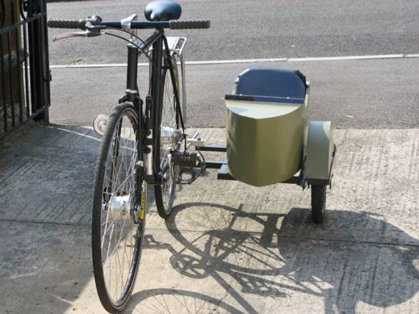
Bicycle with Sidecar


This is not a movie "about the Germans and not the old Soviet great - this vehicle is built not on an industrial scale and in the backyard or in the garage. This cool bike with a sidecar collected Briton Steve Bodiley his own hands. 14 more images after the break...
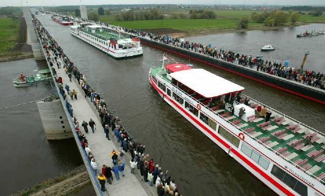
Water Bridge Over River — Magdeburg Water Bridge

Water Bridge Over The River : www.ritemail.blogspot.com

Magdeburg water bridge can rightfully claim to be a revolutionary breakthrough in bridge construction. The idea to build a navigable bridge that would connect Berlin with the ports on the Rhine River, originated in the distant 1870s. Prior to the creation of a specific project it came only in 1920. 04 more images after the break...
Wednesday, May 1, 2013

The Leaning Tower of Abu Dhabi — Capital Gate Building


Capital Gate is an iconic leaning skyscraper located in Abu Dhabi adjacent to the Abu Dhabi National Exhibition Centre. At 160 meter (520 ft) and 35 stories, it is one of the tallest buildings in the city and leans at an astounding 18 degrees to the west, four times than the famous Leaning Tower of Pisa. In June 2010, the Guinness Book of World Records certified Capital Gate as the "World’s furthest leaning man-made tower."

To make this possible, the central core of the building slants in the opposite direction to the lean of the structure, and it straightens as it grows. The building sits on top of a 7-foot-deep concrete base with a dense mesh of reinforced steel. The steel exoskeleton known as the diagrid sits above an extensive distribution of 490 piles that have been drilled 100 feet underground to accommodate the gravitational, wind and seismic pressures caused by the lean of the building.

Capital Gate is an iconic leaning skyscraper located in Abu Dhabi adjacent to the Abu Dhabi National Exhibition Centre. At 160 meter (520 ft) and 35 stories, it is one of the tallest buildings in the city and leans at an astounding 18 degrees to the west, four times than the famous Leaning Tower of Pisa. In June 2010, the Guinness Book of World Records certified Capital Gate as the "World’s furthest leaning man-made tower."

Photo Via — Flicker

The ground-breaking form of Capital Gate is due not only to its lean, but also to its funnel shape. The tower widens as it spirals upwards and outwards. Due to its strange design each hotel room is unique in size and shape, with floor-to-ceiling windows that let guests soak up the best of the sweeping views of the city below.

Capital Gate forms the focal point of the Abu Dhabi National Exhibition Centre complex and the Capital Centre master development, a connected group of 23 towers including branded hotels, commercial buildings, residential and serviced apartment complexes and developments for mixed use. These facilities are built overlooking an urban highway along the south-western shore of Abu Dhabi, with Capital Gate dominating the waterfront from its position at the western edge.

The 35-storey tower, which opened less just a year ago after five years of construction, is fast becoming one of Abu Dhabi's most famous landmarks. 09 more images after the break...

Street Stair Art Around The World


Street Stair Art Around The World

Selected works of street artists performed on the stairs of different cities of the world, 15 more images after the break...

Related Posts Plugin for WordPress, Blogger...